
A great idea for an unusual walk from Amanda Brown: I always imagine a gravelly horror movie voiceover announcing the name Dallowgill whenever I see a sign for this scattered moorland community that lies between Pateley Bridge and Kirkby Malzeard in Nidderdale.
A swirl of mist or a gusty squall would all add to the atmosphere but while at first sight Dallowgill seems just a wide expanse of moorland as you drive over Dallow Moor, it hides the sheltered wooded folds and creases in the landscape alongside the river Laver and its tributaries.
No surprise really given the name apparently originates from monks referring to the place as Dalhagha - Dael meaning valley and haga denoting enclosure - with Gill, meaning ravine added later.
If you do need any more of an incentive to stop and linger longer, then it’s worth setting off on a walk along all, or part, of the Crackpots Mosaic Trail, a 7-miler with 22 beautiful mosaic panels mounted on stones which act as the sign posts for the route.
The mosaics were created in 1997 by the Crackpots artists’ group from Kirkby Malzeard as part of a community project to mark Nidderdale’s new status as an Area of Outstanding Natural Beauty (now called Nidderdale National Landscape).
Each of the mosaics depicts local scenes along with the wildlife and heritage associated with Dallowgill and nearby Laverton.
So along with an image of a curlew, dragonfly and sheep, other mosaics portray a Roman Centurion representing the remains of a soldier discovered embedded in peat on Grewelthorpe Moor in the 1800s; a pint of beer (no doubt in honour of the Drover’s Inn which sadly is no more); and the sighting tower at Carlesmoor which surveyors used during the building of Leighton and Roundhill reservoirs.
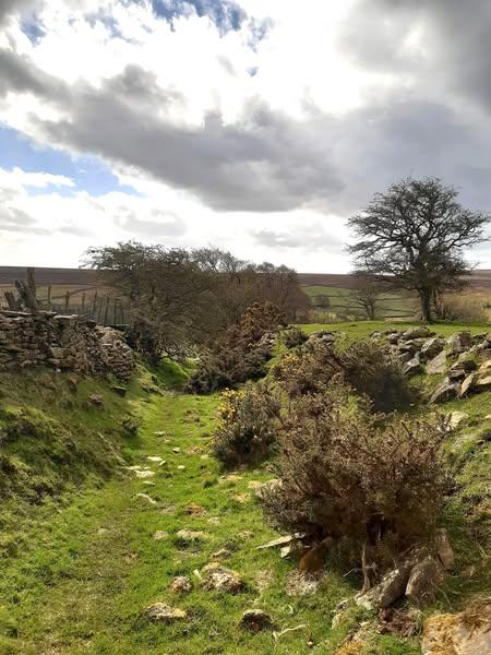
All of the walk is scenic but there’s a lovely stretch that meanders through woods, crosses the River Laver and then emerges onto open fields past Bents House and the buttressed barn where you see a stone wall constructed around and over some larger boulders (I once read this indicates older walls dating back to Mediaeval times but if there any professional dry stone wallers reading this, then probably they can let us know!).
A sunken lane, which in spring is fringed with yellow gorse flowers, leads to a minor road with a fantastic view greeting you as you walk down towards the car park above Tom Corner.

